
Ramsar Wetlands, Coastal and Nearshore
The Ramsar Wetlands, Coastal and Near-shore Subsystem, including the City of Mandurah, is the lifestyle and residential hub of the Region. Many people enjoy the natural wonders of the Peel-Harvey Estuary, lower reaches of the Murray River, Yalgorup National Park and beaches of the Indian Ocean. The Peel Inlet and Harvey Estuary is the largest and most diverse estuarine system in the south-west of Western Australia and is part of the Peel-Yalgorup Ramsar System.

Ramsar 482
Our local Peel-Yalgorup System is the largest and most diverse estuarine complex in Australia’s South West. It was listed as a Ramsar wetland (Global site 482) in 1990.
The Peel-Yalgorup Ramsar System is recognised as a Wetland of International Importance under the Ramsar Convention. The 26 530 ha System meets seven of the nine criteria for listing under the Convention. It supports a huge number and diversity of residential and migratory waterbirds. It provides habitat for fish breeding and nursery grounds for fish, crustacea and birds and rare living ‘rocks’ known as thrombolites. The System comprises the Peel-Harvey Estuary, the lands and lakes of Yalgorup National Park, Lake McLarty, Lake Mealup and Roberts Bay Swamp.

One hundred and four species of waterbirds have been recorded in the Peel-Yalgorup System. Thirty-five of these are international migrants. Some fly up to 24 000 kilometres every year from their breeding grounds in northern Asia to Australia where they spend our summer feeding on the mudflats and foreshores of the Estuary and surrounding wetlands.

Curlew Sandpiper
Calidris ferruginea
Photo: Bill Howard
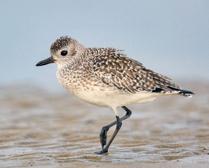
Grey Plover
Pluvialis squatarola
Photo: Bill Howard

Red-necked Stint
Calidris ruficollis
Photo: Bill Howard
The Peel-Yalgorup Ramsar System requires careful management as residential areas continue to grow. Buffers to the wetlands and bushlands need to be protected and recreational use of waterways and foreshores must recognise the principles of Wise Use of Wetlands (Article 3.1 of the Ramsar Convention). Boating and fishing need to be carefully managed.
Increases in salinity and reductions in ground and surface water flows due to bores and declining rainfall are threatening natural assets such as Lake Clifton and its ancient thrombolites. The thrombolites are listed as a critically endangered threatened ecological community for which an Interim Recovery Plan has been prepared.
Wetlands and People Plan
In 2017 the PHCC launched Australia’s first CEPA Action Plan for a Ramsar-listed site – our Wetlands and People Plan. At the centre of the Ramsar philosophy is the “wise use” of wetlands, the conservation and sustainable use of wetlands and all the services they provide, for the benefit of people and nature. The Plan was developed with the support of an expert panel from a range of backgrounds including tourism, planning, local government, social sciences, youth, biodiversity and culture, followed by an extensive consultation process. The Plan’s 4 Goals endeavour to create a brighter long-term future for the wetlands through encouraging wise-use, well-informed decision making, active stewardship and advocacy across all sectors. The Plan will also help the Australian Government meet its obligations as signatories to a number of international agreements (Ramsar, as well as the international Migratory Bird Agreements with Japan, China & the Republic of Korea – JAMBA, CAMBA & ROKAMBA). The PHCC is actively implementing the Wetlands and People Plan, with community support.
ECD Addendum
Describing the ecological character of a wetland ecosystem sets the benchmark for management planning and actions, and so is central to effective management. The Ecological Character Description of the Peel-Yalgorup Ramsar Site was published in 2007, but since then the form and content of the description of the ecological character has changed and there have been updates to listings of threatened species and ecological communities. The (draft) addendum to the Ecological Character Description was produced in 2019 to incorporate these updates and changes to the terminology we use to describe the ecological character of Ramsar Site 482.
Ramsar Baseline Report Card
This report card for the Peel-Yalgorup Ramsar Site is intended to be used as a communications tool to inform the community of the current condition of the Peel-Yalgorup Ramsar Site (Ramsar 482) and catchment. The Ecological Character Description for the Peel- Yalgorup Ramsar Site (Hale and Butcher 2007) specifies 81 parameters and variables as measures of these components and processes for which Limits of Acceptable Change (LAC) may be set. The Report Card, current to 2018, compares information collected from various monitoring programs with these LACs with the result shown according to a traffic light system: green indicates that the measured variables meet the LAC and red indicates that the LAC has not been met. A yellow colour represents that the data is borderline with the LAC indicating that the LAC is met in some respects but not others. Grey indicates that there is insufficient data to assess performance against the LAC, thereby identifying gaps in the monitoring programs.
Complementing the wetlands of the Ramsar System are woodlands of tuart, WA peppermint and other vegetation types that provide habitat for a variety of terrestrial fauna. These include the western ringtail possum (Pseudocheirus occidentalis), a threatened species which had become locally extinct and has been successfully re-introduced into Yalgorup National Park and surrounding areas.

Thrombolite Community
Lake Clifton

Tuart Woodlands
Eucalyptus gomphocephala

Western Ringtail Possum
Pseudocheirus occidentalis
Photo: Jiri Lochman
Statistical Snapshot
For a detailed comparison of current statistics (2020) to previous (2014) click here


- $217 million in annual expenditure on recreational fishing activities
- $40 million in annual expenditure on boat maintenance and operations in the Peel
- $1.8 million in annual revenue generated through storing boats in PYS Marinas
- Between $0.9 million and $1.7 million in annual catch from commercial fishing
- $318.2 million in annual tourism expenditure spent in Mandurah
- $3.15 million derived from the value of 9 commercial fishing licenses

The total monetary value of ecosystem services derived from Peel-Harvey’s coastal and inland wetland ecosystems was quantified in 2013 to be approximately $3.35 billion (2007 prices)[1]. By comparison, the Peel’s Gross Regional Product at the time was estimated at $5.6 billion.
Estimates do not include real estate values which are estimated to drop in value by ~$50,000 per property, should the system collapse again (2010, Peel Estuary and Land Values Near Waterways, an Economic Valuation)
ARC Linkage Research Findings (2019)
The ARC Linkage Research project “Balancing estuarine and societal health in a changing environment” has confirmed the findings of the 2010 Science Strategy for the Peel-Harvey Estuary that ecologically the Estuary and three rivers that flow into it, are all showing very worrying signs. Our rivers are more salty, our species numbers, abundances are all in decline (with marine species increasing), macroalgae is increasing, toxic sediments are increasing. Trouble hotspots are identified.
Future predictions (to 2050) show that a ‘business as usual’ approach in a drying climate will intensify problems. The near-collapse of the Estuary between the 1970s and 1980s due to excessive nutrient loads from the Coastal Plain catchment led the State Government to construct the Dawesville Cut (1994). Whilst the Cut flushes nutrients out of the Estuary, levels of nutrients and sediment entering the lower rivers, particularly the Serpentine River, continue to be high and algal blooms and fish kills are regular occurrences.
The condition and rate of decline of these environments are potentially the most significant indicator of current and future trends having an impact on the Estuary. In terms of strategic assessment and monitoring programs this environment is of critical importance.
Solutions to the Estuary’s water quality problems are known and are achievable but require significant changes in the way that land, particularly on the Coastal Plain is developed and managed. While there are no silver bullets, broadscale amendment of soils and management of fertiliser use provide the greatest opportunities to reduce nutrient pollution entering the rivers and estuarine system (Kelsey, P et. al., 2011 and Environmental Protection Authority, 2008).
Coastal and Nearshore Environments
Framing the Ramsar Site to the west are 83 kilometres of coastal and near-shore environments. This coastal landscape is characterised by tuart woodlands, coastal heath (primary and secondary sand dunes), and sandy beaches. Most of the Region’s coastline is protected within foreshore reserves of varying widths and the Yalgorup National Park. Development of near-coastal areas has occurred to create residential areas, recreational and boating facilities, and the Dawesville Cut.
The Estuary and near-shore environments support a range of wildlife, including dolphins, crabs, fish and birds. Many of these species are iconic and valued by the community and visitors. Commercial fisheries centred at Mandurah and based on estuarine and marine species were valued at $4.38 million per annum in 2010 (Peel Development Commission, 2014).


